


Maverick
GPS Navigation

وصف لـMaverick: GPS Navigation
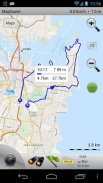
Use offline maps and GPS even without an internet connection. This app is great for hiking, boating, geocaching and other outdoor activities.
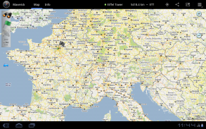
• Multiple global and regional online maps, including: Bing, Yandex, Open Street Maps, OSM Cycle, OSM Public Transport, Multimap (UK), OutdoorActive (Germany, Austria, South Tyrol), Cykloatlas, HikeBikeMap (Germany), Open Piste Map, NearMap (Australia) and many other maps.
All maps automatically cached for offline use. Use Mobile Atlas Creator to download maps or MAPC2MAPC to convert maps from other formats.
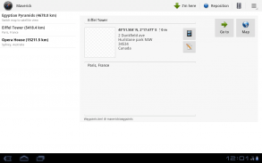
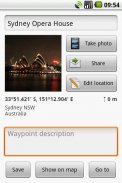
• Share your current or planned position
You can send address, GPS coordinates, link to Google Maps and even map image.
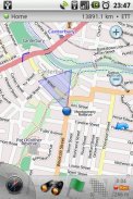
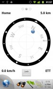
• Navigate easily
Build-in radar shows the direction, distance and estimated time to a point of interest.
• Save places you visit
All waypoint stored in KML file and can be viewed and edited in Google Earth.
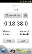
• Record tracks with single tap
Tracks are recorded in GPX format and can be viewed in Google Earth and other software.
• Upload tracks to GPSies
Free account is required for uploading.
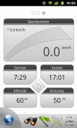
• Trip Computer
Watch speed, altitude, pitch and many other values.
Only in Pro version:
• Unlimited waypoints and tracks
• Lock compass to bearing
• UTM and OSGB grids
• OS Explorer maps
• FourSquare support
We can implement standard Google MapView, but it's limited - no caching and terrain view. If you need it, please email us or leave a comment.
</div> <div jsname="WJz9Hc" style="display:none">استخدام متواجد حاليا الخرائط وتحديد المواقع حتى من دون اتصال بالإنترنت. هذا التطبيق هو عظيم للمشي، ركوب الزوارق، وغيوكاشينغ والأنشطة في الهواء الطلق الأخرى.
• الخرائط على الإنترنت العالمية والإقليمية متعددة، بما في ذلك: بنج، ياندكس، افتح خرائط الشوارع، دورة OSM، OSM المواصلات العامة، Multimap (UK)، OutdoorActive (ألمانيا، النمسا، جنوب تيرول)، Cykloatlas، HikeBikeMap (ألمانيا)، توسيع الزحلقة خريطة ، NearMap (أستراليا) والعديد من الخرائط الأخرى.
جميع الخرائط المخزنة مؤقتا تلقائيا للاستخدام دون اتصال. استخدام موبايل أطلس الخالق لتنزيل الخرائط أو MAPC2MAPC لتحويل الخرائط من غيرها من الأشكال.
• شارك الموقف الحالي أو المخطط الخاص بك
يمكنك إرسال عنوان، الإحداثيات GPS، وصلة لخرائط جوجل وحتى تعيين الصورة.
• تنقل بسهولة
ويظهر البناء في رادار الاتجاه والمسافة والوقت المقدر لنقطة اهتمام.
• حفظ الأماكن التي تزورها
كل إحداثية تخزينها في ملف KML ويمكن الاطلاع وتحريرها في برنامج Google Earth.
• سجل المسارات بنقرة واحدة
يتم تسجيل المسارات في شكل GPX ويمكن الاطلاع في برنامج Google Earth وغيرها من البرامج.
• يتتبع تحميل لGPSies
مطلوب حساب مجاني للتحميل.
• كمبيوتر الرحلة
مشاهدة السرعة والارتفاع، في الملعب وقيم أخرى كثيرة.
فقط في النسخة برو:
• نقاط الطرق والمسارات غير محدود
• قفل البوصلة لتحمل
• UTM وOSGB شبكات
• OS خرائط إكسبلورر
• دعم شخصيات قصص الابطال الخارقين
يمكننا تنفيذ معيار جوجل MapView، لكنه محدود - لا التخزين المؤقت والتضاريس الرأي. إذا كنت في حاجة إليها، يرجى مراسلتنا عبر البريد الإلكتروني أو ترك تعليق.</div> <div class="show-more-end">
Maverick: GPS Navigation - إصدار 2.7.4
(12-10-2015)
Maverick: GPS Navigation - معلومات APK
نُسخة APK: 2.7.4الحزمة: com.codesector.maverick.liteآخر إصدار من Maverick: GPS Navigation
نُسخ أخرى


 4.63
4.63


 3.55
3.55


تطبيقات من الفئة نفسها


